How to Check If a House Is in a Flood Zone by Address, and What the Flood Map Won't Tell You
Look up any address on FEMA's free flood map. Learn how to do it step by step, what each zone letter means, when flood insurance is required, what to ask the seller, and the honest limits of flood maps and flood models.

Written by Toan Vo ·
This article was drafted with AI help, reviewed, and approved by Toan Vo.
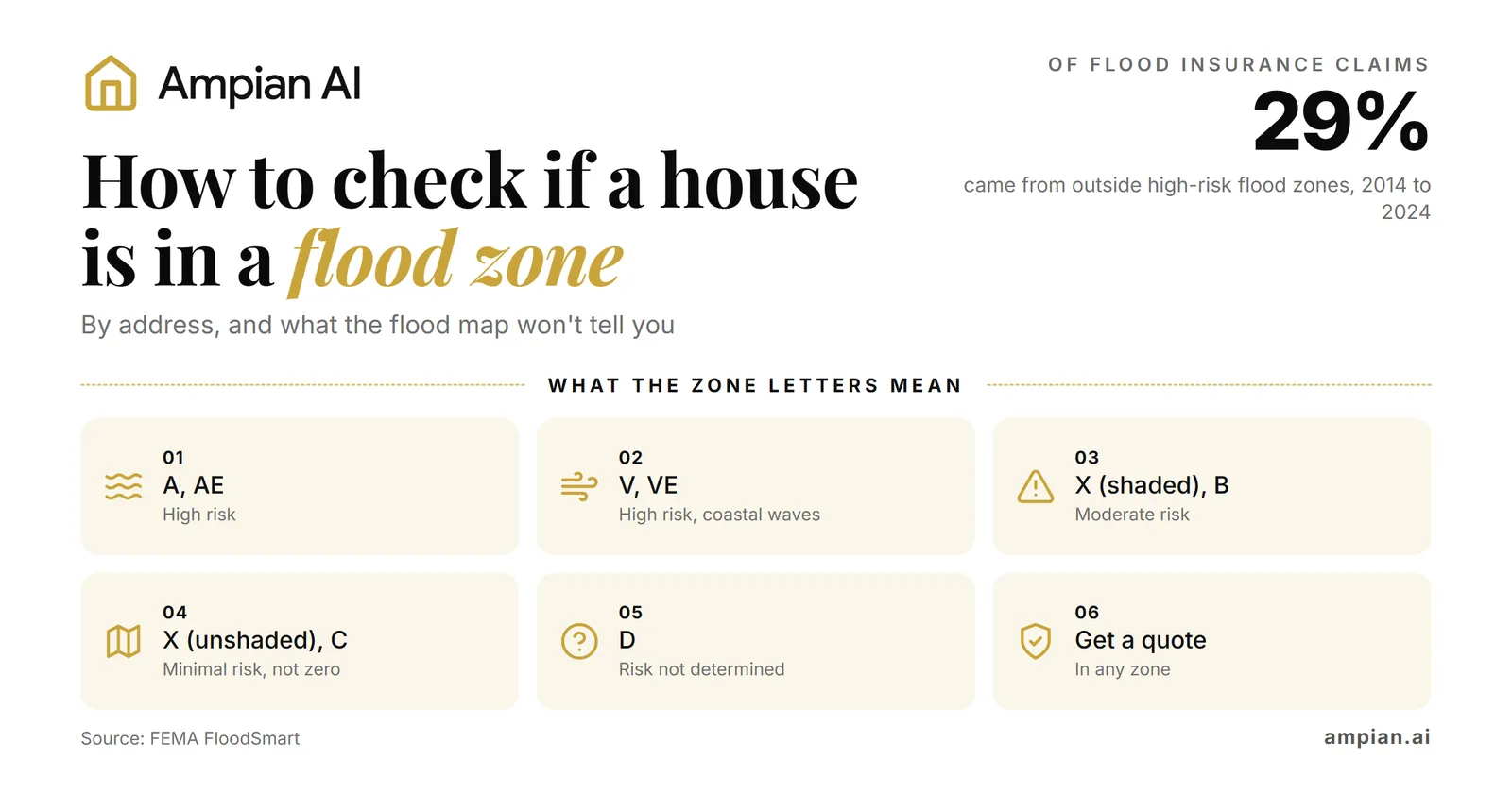
To check if a house is in a flood zone, enter its address into FEMA’s free Flood Map Service Center and find the zone covering the building. Then check its flood history and insurance costs. FEMA reports that 29% of National Flood Insurance Program (NFIP) claims from 2014 to 2024 came from areas outside its current high-risk flood zones1.
This guide explains the address lookup, flood zone letters, insurance costs, and questions to ask before buying. It also explains how Ampian AI brings FEMA flood information and other hazard ratings into one report.
Key takeaways
- FEMA’s Flood Map Service Center provides official flood maps you can search by address for free2.
- Zones beginning with A or V are high-risk flood areas. Flood insurance is generally required for homes there with government-backed mortgages, in communities participating in the NFIP10.
- Zone X means lower mapped risk, not zero risk. Zone D means FEMA has not determined the flood risk9.
- The zone letter does not tell you the insurance price. NFIP pricing considers the individual building and several sources of flooding11.
- Ask the seller about past flooding, claims, current coverage, and any elevation certificate. Texas’s disclosure form includes flood-history and insurance questions16.
- Maps can miss hazards, and flood models can produce different results for the same location. In one Los Angeles study, two models agreed on which properties were at risk only 24% of the time18.
Step by step: look up the address on FEMA’s flood map
Start with FEMA’s Flood Map Service Center. Search the address, open the map, and check the house’s location against the zone boundaries3.
- Open the Flood Map Service Center. Go to msc.fema.gov and enter the home’s address in the address search box2.
- Read the zone. Find the zone covering the building. Record its letter, the map’s effective date, and the FIRM panel number, which identifies the official Flood Insurance Rate Map sheet5.
- Check the building, not just the address marker. Use FEMA’s National Flood Hazard Layer viewer to explore the mapped boundaries4. If a boundary crosses the property or lies close to the house, ask the local floodplain manager to help confirm the building’s zone. This is the city or county official responsible for local floodplain rules.
- Check for proposed map changes. Use “Search All Products” on the same site to see every flood map product for the community, including any preliminary (draft) maps2. A preliminary map can’t be used for an official flood-zone determination5, but it can show where the lines may move. FEMA suggests checking whether your community has “a flood map update underway”10.
- Save a copy. Create a FIRMette, a full-scale section of the official map that you make yourself and print on a home printer5. Keep it with your house research.
The National Flood Hazard Layer covers areas where “over 90%” of the U.S. population lives, and FEMA adds new and revised data “continuously”4. If your address shows no digital data, call the local floodplain administrator, which FEMA names as the other place to find your map10.
Before you offer: Save the FIRMette, record the zone and map details, and check for a preliminary map. If the building is near a boundary, confirm its location with the local floodplain manager and ask your lender about insurance requirements.
What the flood zone letters mean
FEMA uses letters to describe mapped flood hazards. These labels help you understand the map, but they do not describe every possible source of flooding.
- High-risk zones (A, AE, AH, AO, AR, A99). These are special flood hazard areas associated with a flood that has a 1% chance in any given year. This is often called the “100-year flood”6. Over a 30-year mortgage, homes in these areas have “a 1 in 4 chance of flooding at least once”1. Zone A does not show flood depths or a base flood elevation because it has not been studied in detail3. Zone AE includes a base flood elevation: the estimated water level during a flood with a 1% annual chance7.
- High-risk coastal zones (V, VE). These areas face the 1% annual-chance flood and an additional hazard from storm waves8. They have a 26% chance of flooding over the life of a 30-year mortgage8.
- Moderate risk: Zone X (shaded), also Zone B. Land between the boundaries of the 1%6 and 0.2% annual-chance floods. The latter is often called the “500-year flood”6.
- Minimal risk: Zone X (unshaded), also Zone C. Areas outside the mapped 0.2% annual-chance flood boundary6. Local drainage problems and water collecting on the ground can still cause flooding10.
- Undetermined: Zone D. Areas where flooding is possible, but FEMA has not completed an analysis to determine the risk9.
The zone also affects mortgage requirements. In NFIP-participating communities, flood insurance is generally required for a home in an A or V zone if it has a government-backed mortgage10. Ask your lender whether it requires flood insurance outside these zones.
A “minimal” zone is not the same as “no flood risk”
A house in Zone X can still flood, and the damage can be costly. FEMA’s FloodSmart site says flood insurance claims from outside high-risk flood areas made up 29% of all National Flood Insurance Program claims from 2014 to 20241. Over the past 20 years, 99% of U.S. counties had a flood event1. From 2020 to 2024, the average payment on a flood claim was $82,6141.
FEMA also states that “most homeowners insurance excludes flood damage”1. So if water gets in, the policy you buy for the house usually won’t pay for it. Ask your insurance agent what the policy covers and whether you need separate flood coverage.
FEMA’s free flood claims tool shows how many flood insurance claims were paid in each county since 1980. FEMA’s own note on that page: “Wherever it rains, it can flood”15. The tool counts only claims paid by the federal program, so it misses damage that was uninsured or privately insured15.
For help adding flood insurance to your monthly budget, see section 6 of our hidden costs guide.
Before you offer: Request a flood insurance quote even if the house is in Zone X. Use FEMA’s claims tool to check the county’s claim history, then ask about flooding on the property and nearby streets.
How flood insurance is priced now (Risk Rating 2.0)
FEMA changed how federal flood insurance is priced. New policies moved to the new method on October 1, 2021, and FEMA completed the transition on April 1, 202311. Under it, “the NFIP’s pricing approach does not use flood zones to determine flood risk.” It looks at flood frequency, several flood types including “heavy rainfall”, distance to water, and the home itself, such as its elevation and the cost to rebuild11.
What this means for a buyer:
- Two houses in the same zone can get very different prices. The zone tells you whether insurance is required. The quote tells you what it costs.
- NFIP rates are consistent across providers. For the same property information and coverage, insurers selling NFIP policies use the same rates.12
- Most annual increases are capped. Most existing NFIP policies have an 18% limit on annual premium increases. Exceptions apply, so ask your agent how the rule affects the policy11.
- Taking over the seller’s policy may preserve a lower rate. If the policy can transfer, you may keep its gradual increases toward the full-risk rate, the price based on the home’s assessed flood risk. A new policy generally starts at that rate, less any eligible discounts10.
- Check the start date and coverage limits. Coverage normally starts 30 days after you buy it, with exceptions that include buying coverage in connection with obtaining or changing a mortgage12. Confirm the start date with your agent. For a typical single-family home, available limits are $250,00012 for the building and $100,00012 for belongings; these coverages are generally purchased separately.
Before you offer: Get a written quote for the house. If the seller has an NFIP policy, ask the insurer whether you can take it over and what your cost would be.
Check the wider area: FEMA’s National Risk Index
FEMA’s National Risk Index compares risk from 18 natural hazards across counties and census tracts. A census tract is a statistical area containing many properties. Its rating describes the wider area and cannot determine the risk to one house14. Its December 2025 update rebuilt the inland flooding rating “to incorporate pluvial as well as fluvial flood hazards,” meaning flooding from heavy rain as well as from rivers14.
One change to know: FEMA says “the National Risk Index application is no longer available.” The data now sits in FEMA’s Resilience Analysis and Planning Tool14. Use the index to compare areas, and the flood map and a quote to judge the house.
Ask the seller: claims, flood insurance and an elevation certificate
The seller may know about flooding and repairs that do not appear on a map. Ask these three questions in writing:
- Has the house ever flooded, and was a claim filed? Texas puts these on the seller’s disclosure form. It asks “Have you (Seller) ever filed a claim for flood damage to the property with any insurance provider, including the National Flood Insurance Program (NFIP)?” and whether the seller ever got help from FEMA or the U.S. Small Business Administration for flood damage. The form also asks about “present flood insurance coverage” and whether the property is in the 100-year or 500-year floodplain16. Disclosure rules differ from state to state, so ask your agent what your state’s form covers, and ask these questions anyway if it doesn’t.
- Do you carry flood insurance now, and what does it cost? Ask for the most recent declarations page, which summarizes the policy’s coverage and price. If it is an NFIP policy, ask the insurer whether it can transfer to you10. The seller’s current payment is not a quote for your coverage.
- Is there an elevation certificate? This document records the building’s height relative to expected flood levels. Ask the local floodplain manager whether one is on file. If needed, a qualified surveyor, engineer, or architect can prepare one. An existing certificate may help identify insurance discounts, but it does not guarantee a lower price13.
Before you offer: Send these questions to the listing agent and request supporting records. Ask the city or county whether an elevation certificate is available for the address.
The honest limits of flood maps and flood models
FEMA maps are the official starting point for flood-zone checks. They have limits that matter when you are deciding whether to buy.
Maps age. FEMA’s map site says flood maps “are continually updated” and that information you download “may change or become superseded by new maps over time”2. A Federal Reserve Bank of New York analysis found that “a quarter of all maps were fifteen years old in 2022 and over half were more than five years old”17. New construction and changing weather patterns can change how water flows and drains, which is why FEMA tells owners to check their map every year10.
Rain flooding is often not on the map. A 2024 peer-reviewed study in Earth’s Future found that FEMA’s flood insurance rate maps “do not capture all hazard drivers” and “have been updated too infrequently to keep pace with changes in land use and climate”18. A street that floods in a heavy downpour, far from any river or coast, can still be mapped as minimal risk. FEMA itself notes that minimal-risk Zone C areas “may have ponding and local drainage problems”10. FEMA’s pricing method now counts heavy rainfall11, and its risk index added rain flooding in December 202514.
Flood models disagree with each other. Private flood models try to fill these gaps, but they don’t agree. The same 2024 study compared First Street’s national flood data with a detailed local model for Los Angeles County and found “a Model Agreement Index of only 24%,” roughly a 1 in 4 chance that the two agreed on which properties were at risk18. A Bloomberg comparison of two flood models “found they matched just 21% of the time”19. And when a U.K. industry group had 13 climate-risk companies rate the same 100 properties, Bloomberg reported: “The ratings were all over the place”19.
Use the map, local flood records, the seller’s disclosures, and any elevation certificate together. An insurance quote helps you budget, but it is not a guarantee of safety. For other ways to research hazards, see where buyers can still check climate risk now that Zillow removed its scores in our guide to flood and wildfire risk after Zillow’s climate scores.
Before you offer: Follow up on reports of street flooding even if the map shows minimal risk. Ask neighbors about past events, request local drainage records, and have the inspector check for water damage and ground that slopes toward the house.
How Ampian AI checks this
FEMA’s maps and claims tool are free to use. However, reviewing several sources for every home on your list takes time. The Environmental Risk section of our Ampian AI Zoning Oracle report puts the flood line next to the other hazards for one address.
In our free sample, the Redondo Beach home reads Flood: Minimal and Earthquake: Relatively High20. The flood line comes from FEMA’s National Flood Hazard Layer at the parcel level. The other hazard ratings come from FEMA’s National Risk Index, a tract-level rating and not a parcel-precise determination20.
The report provides a starting point for further checks and shares the limits of its source data. It does not provide a flood insurance quote or replace the seller’s records, an elevation certificate, or local verification20. See Pricing for the current report options.
Frequently asked questions
What does flood zone X mean?
Do I need flood insurance if the house is not in a flood zone?
What is the difference between flood zone A and AE?
Can I take over the seller’s flood insurance policy?
You may be able to take over an existing NFIP policy. If its price is still increasing gradually toward the full-risk rate, a transfer may preserve that arrangement. Ask the insurer to confirm eligibility, price, coverage, and the transfer process before closing10.
Sources
- FEMA FloodSmart, What is My Flood Risk
- FEMA Flood Map Service Center, Welcome page
- FEMA, Flood maps for homeowners and renters
- FEMA, National Flood Hazard Layer
- FEMA Flood Map Service Center, Frequently Asked Questions
- FEMA glossary, Flood zones
- FEMA glossary, Zone AE and A1-30
- FEMA glossary, Zone VE and V1-30
- FEMA glossary, Zone D
- FEMA FloodSmart, What is My Flood Zone
- FEMA, Risk Rating 2.0
- FEMA FloodSmart, What you need to know about buying flood insurance
- FEMA FloodSmart, Get an elevation certificate
- FEMA, National Risk Index for Natural Hazards, last updated January 7, 2026
- FEMA FloodSmart, Historical NFIP Claims Information and Trends
- Texas Real Estate Commission, Seller's Disclosure Notice (TREC No. 55-1)
- Federal Reserve Bank of New York, Liberty Street Economics, Potential Flood Map Inaccuracies in the Fed's Second District, November 10, 2023
- Schubert, Mach and Sanders, National-Scale Flood Hazard Data Unfit for Urban Risk Management, Earth's Future, 2024
- Insurance Journal (Bloomberg), Zillow Deleting Home Climate Risk Scores Reveals Limits of Flood, Fire Data, December 10, 2025
- Ampian AI, Zoning Oracle sample report